- California Assembly OKs highest minimum wage in nation
- S. Korea unveils first graphic cigarette warnings
- US joins with South Korea, Japan in bid to deter North Korea
- LPGA golfer Chun In-gee finally back in action
- S. Korea won’t be top seed in final World Cup qualification round
- US men’s soccer misses 2nd straight Olympics
- US back on track in qualifying with 4-0 win over Guatemala
- High-intensity workout injuries spawn cottage industry
- CDC expands range of Zika mosquitoes into parts of Northeast
- Who knew? ‘The Walking Dead’ is helping families connect
Typhoon Khanun to land on S. Korea’s southeast coast this week
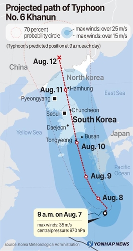
Typhoon Khanun is forecast to land on South Korea’s southeastern coast later this week, packing winds as fast as 44 meters per second, the weather agency said Monday.
Khanun, which passed the ocean 330 kilometers east-northeast of Japan’s Okinawa at 9 a.m., is expected to advance north to reach waters 90 km southwest of Busan at 9 p.m. on Thursday, the Korea Meteorological Administration said.
When it nears Busan, the typhoon may be packing strong winds that have a maximum speed between 33 meters per second and 44 meters per second, a level that is strong enough to derail a running train, the agency said, adding the forecast is subject to change.
From South Korea’s southeastern coast, Khanun is expected to advance northward, passing the Korean Peninsula vertically and bringing strong winds faster than 15 m/s across South Korea.
At 9 a.m. Friday, the typhoon may reach 40 km northwest of North Korea’s Hamhung, and at the same time on Saturday, it may pass by China’s northeast and diminish into an extratropical cyclone.
Regions across South Korea will experience strong winds and rains under the influence of Khanun through Thursday, with the southeast coast expected to see strong winds of around 40 m/s and winds between 15 m/s and 35 m/s for the rest of the regions.
Between Wednesday and Thursday, Gangwon Province may see rains of up to 400 millimeters, while the rest of the regions may receive between 50 mm and 200 mm of rain, the agency said.

According to the interior ministry, the government’s Central Disaster and Safety Countermeasures Headquarters had raised its disaster readiness alert level up a notch to level 2 from level 1 as of 6 p.m. in response to the typhoon’s looming landfall.
Interior Minister Lee Sang-min said the government will focus its administrative power on preventing casualties by restricting access to areas prone to disasters, such as mountains, underpasses and old reservoir zones.
Lee added authorities plan to preemptively evacuate residents in high-risk areas to prevent casualties.


