- California Assembly OKs highest minimum wage in nation
- S. Korea unveils first graphic cigarette warnings
- US joins with South Korea, Japan in bid to deter North Korea
- LPGA golfer Chun In-gee finally back in action
- S. Korea won’t be top seed in final World Cup qualification round
- US men’s soccer misses 2nd straight Olympics
- US back on track in qualifying with 4-0 win over Guatemala
- High-intensity workout injuries spawn cottage industry
- CDC expands range of Zika mosquitoes into parts of Northeast
- Who knew? ‘The Walking Dead’ is helping families connect
Super Typhoon Hinnamnor forecast to make landfall on southern S. Korea next week
Typhoon Hinnamnor is largely forecast to make landfall on southern South Korea early next week, with the possibility of it becoming the strongest storm ever to hit the country, the state weather agency said Friday.
The super typhoon is forecast to land on the southern coast of South Gyeongsang Province during the morning of next Tuesday, according to the Korea Meteorological Administration (KMA).
The typhoon, the 11th this year, is currently classified as “super strong,” the strongest out of its four-tier system, according to the agency. It was located in waters 420 kilometers southeast of Taipei as of 9 a.m. Friday.
Prime Minister Han Duck-soo instructed relevant ministries and government agencies to preemptively come up with response measures to minimize damage from the typhoon.
Han told officials that relevant authorities should “ensure that damages to people and property must be minimized through thorough prior control and evacuation guidance for dangerous areas,” the prime minister’s office said in a statement.
Typhoon Hinnamnor is expected to strengthen as it continues on a path northward before hitting the country as a “strong” typhoon, the third strongest with an atmospheric pressure of 950 hectopascals at its center and a maximum wind speed of 43 meters per second, the KMA said.
The forecast indicates the typhoon will leave the Korean Peninsula late Tuesday night over the East Sea, yet the path is uncertain, the KMA said.
“There is the possibility of damage that has never been seen here before,” Woo Jin-kyu, a KMA official, told a press briefing, urging the people to brace for heavy rains and wind.
The KMA warned of coastal swells and rain across all parts of the country, escalating from its earlier forecast that the impact will be limited to the country’s southern part.
Heavy rain is expected across the country as the typhoon absorbs moisture from a newly formed tropical depression before coming closest to the Korean Peninsula.
The southeastern part of Jeju is currently seeing precipitation levels ranging between 10 and 20 millimeters per hour, with the level expected to reach up to between 100 and 250 mm, between Friday and Sunday, the KMA said.
Seoul and the surrounding area are expected to witness between 20 and 70 mm of rain Sunday, the authorities said.

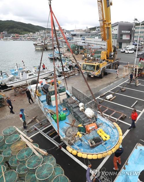
A fishing boat is moved onto land at a port in the southeastern city of Ulsan on Sept. 2, 2022, ahead of the arrival of Typhoon Hinnamnor. (Yonhap)


